Sunday, November 23, 2008

Glentress mincing

I was up until 5am watching Ricky "Hitman" Hatton take Paulii Malanagi to boxin school in there world title fight knowing that i had to be up at 9am to head over to Glentress for a day's riding.
I looked out the window just before i went to bed and could't belive that it was snowing, it was about 3inches, 3hrs ago it had just been a cold and dull night and now i was loking at a mini blizzard. I got up and it was white i thought about cancelling but decided not to as it had been planned with Malcolm earlier in the week. He turned up and we headed for Glentress. 

The weather was crap at glentress dull and wet. We set off and straight away i was getting a wet arse from all the wet spray coming up of my tyre i new this was gonna be a wet one. We made it up to the top of spooky woods eventually, Malcolm's fitness almost non-existent Ha Ha (to much letting the girlfriemd ran about after you i think.) 

www.7stanes.gov.uk
We headed down the spooky woods run whitch is like a big boy's bmx train with it's perfectly smooth berms and fast flowing motorways, it's not really what i like to ride but you can't knock it for what it is and it's perfect for beginers or novices (not that im any kind of super rider) or just generally getting out with your mates for a laugh. I was soaking after the first run down and my legs were freezing as we pused back up for another run down. We done 2 loops of spooky woods then headed down the rest of the red/black runs, the 2 run's after spooky woods trail are my favourites because they have some fast rooty/rocky sections in them and you can pick some good flowing speed up. We headed up to the Black run and i showed Malcolm where the north shore (ish) stuff is then we made are way down the black runs, these are good steepish descents and have the odd rock garden tight fast wood sections so you get a good mixture of everything here. Once at the bottom we had to make are way up to the van, a little ride up the road taking about 5min.
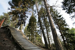
We got changed and headed to the hub cafe for a cuppa and a roll, the prices in this cafe have gone through the roof boardering on mental they want £7 for a full english breakfast!! i ordered a takeaway Latte and was handed the smallest takeaway container i have seen smaler than the petrol station one's and was charged £1.60, 2 sipps and it was gone.... Im not going back there again ripping off Bas*@rds. Overall it was a good day and now im knackered going for a shower and heading to my scratcher....
Posted by Picasa

Wednesday, November 19, 2008

Cheviot tester


Learmonth and myself tackle a night on Lamb hill.

We decided to head up into the cheviots a couple of weeks ago just for 1 night to test our map reading, weather endurance and to overall, get back into the swing of things up on the hills. 

We decide that Saturday the 15th was the best time for the both of us so the date was set and i was buzzing to get out there for the night. We set off from Berwick at 13:30 and was at Byrness for about 15:00 this is where we would start from en-route to the refuge hut on lamb hill about 9miles away. We both had day sacks with enough gear just in-case something went wrong, if something is going to go wrong it's usually the short trips where you might just switch off a bit.
We set off at 15:15 and joined the Pennine way, the going was good and the route is well sign posted so there was nothing to worry about we just bimbled on buzzing to be out there. You get a good view of the reservoir to your let and immediately to your right is the military's otterburn training ground (a no go zone). As we went on the light started to fade away and the wind picked up dropping the temperature to around 6 above it started raining to so out came the jackets but it never lasted long. After 2 hours walking the light was gone and what was a comfortable walk with signposts marking the route became an altogether different occasion. We decided to give ourselves a challenge by not using torches to see where we were going and only having the use of the map with no compass or GPS allowed. After passing the roman ruins the going got tough the ground underfoot become riddled with marsh outcrops, also the map reading became hard as the place is so bleak and it was dark. We plodded on struggling to keep on course due to the wide marsh areas, we pulled the map out at a cairn and found the track again we were about 2km away from the refuge hut on lamb hill to north and feelings were good. We set off again and 20min in we lost the track in a huge marsh area, we presumed that where we were on the map we should be veering off to the righ slightlyt as the track did on the map so we spread out a bit to see if we could pick up the track, we found a well walked track and decided that it was the one we were looking for so again we walked on. After walking for about 20min we stopped at a fence line and looked at each other both thinking the same thing.....we are not in the right place...We decided to get the compass out and see whats what, when we saw that the compass was pointing south we never believed it so we got the spare out, again the compass showed we were heading south it was time to get a grid reference so we powered up the Garmin and once it had a fix it had accuracy to within 6meters of our location. Once we had the grid we checked it to the map and couldn't believe where it was putting us on the map and the place where it had put us we did not want to believe as there was no fence line showing on the map. The fence looked allot older than the map so again we were confused and disorientated, we decided to believe the gear (as you always should) and took a bearing to the refuge hut from where we were we decide that we should pace out 100m then check our Garmin again and it confirmed that we were heading towards the refuge hut we carried on and made the refuge hut about 30min later after crossing more marshy ground.
The refuge hut on Lamb is small approx 12ft x 8ft wide and placed in the centre of a saddle, 
In the hut we got the wet gear off and hung it up. After that we got the food on the go i had spicy meatballs and Craig had soup and something else i cant remember, once sorted we got into our Baggies chatted for a bit about what had went on then crashed out for the night.
In the morning the weather was great and the temperature was 4'C so it was nippy but OK. We packed up had a brew took a picture and left the hut around 8am. We walked along the pennine way to the cairn we had been at the night before and realised where we had gone wrong, we checked the map at this point and kicked ourselves for being to confident the night before and just assuming we were going in the wright direction. After a good walk and nice weather we got back to Byrness around about 11:30-12:00am and headed home.

If the weather had changed that night when we were lost things could of been allot worse for us, you should never try and feel your way around the hills especially in an area so bleak as the Cheviot's.

Lessons learned from a one nighter:
  • When it gets dark get the map & compass and walk to a bearing and always check it.
  • Always trust your equipment and always carry a back up compass.
  • Never assume anything.
  • No matter how short the walk a good route card would of made the difference.
  • And always carry hot chocolate it makes all the difference.

Monday, November 17, 2008

Preperations For New zealand

Flights are booked for the 23rd Jan 2008 and now im heading into town to pay for my camper.

Thursday, May 22, 2008

Fort william DH first timer

Date: 12/05/08
Location: Fort William / Nevis Range/ Anoch moorWell today’s journey started at 6:30am and ended at 12:05pm and the distance covered? 190miles. Now in France or Switzerland I can cover 190 miles in approx two and a half hours so why in this country does it not only take 3 times as long and is also more expensive i.e. fuel, tax etc. Ok travelling moan aside I’m about to ride one of the best DH tracks this side of the hemisphere and I can’t wait, finally I reach Fort William. As you drive through the town of Fort William you can’t help but notice how nice the place is with the town on one side and loch on the other its very welcoming and comfortable. To get to Anoch Moor you head out of Fort William heading for the Nevis range its only a 10min drive from the town centre you pick up signs for the Nevis range and turn of the main road passing the pikeys on the way up to the car park and arriving at the Gondola station. Once I arrived at the gondola station at the Nevis range I was eager to get on the bike, the weather is great the sun is shining the sky has no clouds and its warm what more could you want. I meet up with Steve and Kris who have just finished their second run and after paying my £21 pound multitrip pass we head round the back of the Gondola station to get the bikes on and get up the hill, the first thing I notice is the strange way the bikes go on the lifts, you place the front of the saddle through an eyelet and that’s it so If you go up there make sure your saddle is tight on its a good system though as it allows three bikes on and all three people inside comfortably. The lift up takes about 15min but can be longer if there are bus loads of old people there! Be prepared to sit in the lifts a little longer as they keep slowing, starting and stopping for them getting on and off. Once at the top you walk out of the gondola station and have a 2 min push to the start of the DH track. There is a cafe there and the views from the cafe balcony are amazing on a clear day like today you can also get a good look at the top half of the track from there. The start is a wooden platform raised about 1 meter from the ground and it leads off to one of the best downhill tracks going. The ride down has everything that a world class DH track should have, it has rocks roots fast corners technical corners off camber corners , jumps step downs etc you name it this track has it, its physically demanding and by the time you are half way down you start to realise that this is no normal DH track its full on all the way down and there is no rest bite your arms and shoulders are aching with the constant pounding and your brain is on overdrive trying to pick the lines that well keep you flowing and missing the wheel busting rocks. This track is mental it’s just one thing after another DH mountain biking at its best. Dropping down onto the lower section and into the woods you start to notice you’re getting some forearm pump and braking is becoming less efficient but you have to concentrate as you’re in with the roots n rocks and one mistake here could send you into the realm of gravity assisted free fall. Clear the woods over one last tricky rocky section and your onto the fast section now take a breather turn left then right and get hard on the pedals over the small jumps carrying your speed well hit the hip jump and style it big time drop back down and you’re on the pedals again ready for the 2 table tops over them and pedal hard for the hip/double you can clear it but you have to be going good and commit to it, some people come up short but it’s just a heavy landing and it tests your shocks to the max as I found on my first run. Along the final stretch up high over the jump and onto the elevator a steep section that you need to commit too to get the most fun out off, you must be at 40mph at this point, down the elevator over the jump and land in the bowl which is part of the 4X track two more drop offs and hard on the brakes trying to stop before the metal fence. Job done smile and pat yourself on the back because that’s one of the best DH tracks you will ever ride. The whole ride for a pro would last about 4:50 for a good rider it will take about 5:15 – 6:30 and for anyone else it would just be an achievement finishing such a good track.
Powered By Blogger